Introduction
The majority of Indian property buyers base their purchase decisions on three factors which include location, price, and appreciation potential. The majority of people do not conduct serious assessments of flood risk until severe monsoon rains demonstrate the poor choice they made. Flood risk has become a nationwide issue which affects different areas in India starting from Mumbai's yearly waterlogging and continuing to Chennai's urban flood events and Gurugram's drainage issues and extending to smaller towns that experience sudden flash floods. The increasing urban population together with diminishing lake areas and obstructed natural drainage systems and heavy rainfall patterns creates new dangers that affect residential safety. Flooding has two main effects because it destroys furniture and vehicles. The building suffers damage which results in higher insurance costs and reduced resale value while people experience daily mental distress. Buyers retain the memory of once-in-five-year water entry into the society compound which creates a lasting impression that influences market behavior. Flood risk assessment should become a required evaluation element for home selection on Property Aaj through its website (https://www.propertyaaj.com). The assessment process of flood risk requires practical and intelligent evaluation methods which need to be implemented before property selection in Tier 1 through Tier 3 cities.
Understand the Local Flood History
The initial research task requires investigators to examine past flooding events that affected the local area. Select micro-markets in Tier 1 cities which include Mumbai and Chennai and Bengaluru and Delhi NCR face persistent waterlogging issues. Low-lying areas near rivers and creeks and reclaimed land experience frequent flooding problems in particular situations. The drainage systems from older times in Lucknow and Kochi and Surat experience difficulties during intense rainfall events. The insufficient stormwater management system in Tier 3 towns causes them to experience sudden flash floods. Local residents know the most about their area. People who deal with sales represent a better standard of truthfulness. Investigate news articles which cover flooding incidents that occurred in that region. The locality which appears in monsoon news reports needs to be treated as an important matter. A single major flood disaster creates lasting effects that reduce both residential quality and property resale value in the affected area.
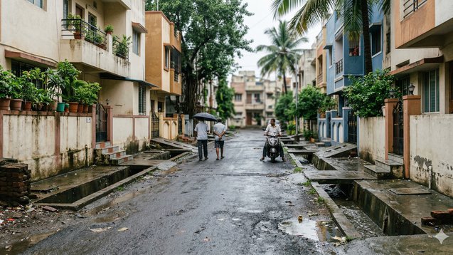
Elevations and Topography must be examined
Water follows a downhill path. Elevation information helps to maintain understanding of base points.The construction process in Tier 1 cities needs to consider existing natural slopes. Natural depressions and areas close to water bodies create higher risk conditions for properties. The suburban development in Tier 2 cities needs to create new areas on land which used to be agricultural or marshy. The absence of drainage planning in Tier 3 towns creates a situation where low-lying areas become more susceptible to flooding. The road levels need to be monitored during the property inspection. Does the structure stand lower than the main street? Does the path slope downwards toward the entrance point? The observer needs to determine whether the basement parking space exists underneath the street level which surrounds the area. You can use basic online elevation maps to assess how the site elevation compares with its surrounding locations. The slightly elevated property provides major safety benefits to people who experience heavy rain conditions.
Assess Drainage Infrastructure
Flooding occurs when rivers overflow their banks. Flooding happens because drainage systems do not function properly. Stormwater drains in Tier 1 cities face two problems which include becoming blocked by debris and experiencing system failures during heavy rain. Newly developing areas in Tier 2 cities still require their drainage systems to reach full operational capacity. Open drains in Tier 3 towns become blocked because of their design which allows debris to accumulate. The inspection needs you to check all roadside drainage systems. Are they wide and covered? What is the condition of the building? The property shows evidence of water that has remained still because it left marks on the walls and compound gates. Inquire with the developer about the project, including its methods for managing stormwater. Modern townships include internal drainage networks and rainwater harvesting systems and water exit planning. Good drainage design creates a major reduction in flood risk.
Evaluate Proximity to Water Bodies
People find waterfront locations attractive when they live near lakes, rivers, or coastal areas. IIn Mumbai and Chennai, which are Tier 1 cities, people who live close to creeks and coastal areas face heightened flood danger during storms with heavy rain and high tides. The lake areas in Bengaluru and Hyderabad have experienced severe flooding problems because of illegal land development that occurred in nearby regions. Rivers and canals in Tier 2 and Tier 3 towns experience overflow problems during monsoon season which occurs at their highest intensity. The property needs assessment to determine its location within floodplain areas. The local municipal authorities publish flood-prone areas on their official flood maps. Extreme rainfall events bring about sudden changes to water body conditions which remain calm throughout most of the year. People find the water views to be stunning and beautiful. Water entry into your home is not. Make sure that your life choices provide you with both safety and attractive lifestyle options.
Inspect Basement and Ground Floor Design
Flooding poses a serious threat to basement areas during flood events. Many high-rise apartments in Tier 1 cities feature basement parking which operates as their primary parking area. Heavy rainfall will cause water accumulation when the entry ramp has a steep downward slope and lacks sufficient water protection barriers. In Tier 2 cities, mid-rise projects may establish semi-basements as building components. Ground-level parking serves as the primary parking method for Tier 3 buildings, which becomes vulnerable to flooding during road level increases. The building should be examined to determine whether it has installed sump pumps together with flood protection systems. The building owner should provide information about previous basement flooding incidents. Inspect the walls for water stains and repair patches. Flood-prone areas require ground-floor unit buyers to practice extreme caution. Residents should select upper floors as their safest option in these locations. The importance of design details exceeds what brochures deliver.
Study Urban Development Patterns
The process of urban development leads to a higher possibility of flooding. The construction activities in Tier 1 cities have decreased both open spaces and natural drainage systems. The conversion of farmland to other uses in Tier 2 cities leads to a total loss of water absorption capacity. The unplanned expansion of Tier 3 towns takes place near highways and industrial areas because the towns lack proper drainage improvements. Check whether nearby land is still under development. Construction sites that lack adequate runoff management systems create temporary water drainage problems for nearby residential areas. Check the local master plans, which exist if they are available. The construction of a large commercial complex in proximity to your location will create drainage flow changes that you need to assess. The risk of flooding increases as cities continue to develop.
Consider Insurance and Long-Term Costs
Flood-prone areas require both higher upkeep requirements and increased insurance expenses. The insurance costs for properties located in designated flood zones within Tier 1 cities will experience an upward trend. The maintenance costs of properties in Tier 2 and Tier 3 markets increase because of repeated water damage which decreases their structural lifespan. Water damage to buildings results in foundation deterioration and electrical system destruction and equipment components experiencing faster operational breakdowns. The resale value of a property declines over time because potential buyers develop reservations about the property's worth. Property Aaj (https://www.propertyaaj.com) listing displays two price points which buyers should use to assess properties located in more elevated regions and more protected areas. The small premium charged at the beginning will provide buyers with savings that exceed their initial investment during their ownership. Smart investment strategy requires establishing mechanisms for risk reduction.
Talk to Society Management or Neighbors
Society Management needs to solve your issues, so you should contact them to get assistance from your neighbors. Existing residents are the best source of truth. The resident welfare associations which operate in Tier 1 apartment complexes keep records about all flooding incidents which have occurred in their locations. Neighbors in Tier 2 and Tier 3 communities share their genuine monsoon experience details with others. You should ask precise questions. Did water enter the basement? How long did it take to drain? What impact did the power outage have on the system? What impact did the power outage have on the system? First-hand feedback often reveals more than official responses. Verified information brings peace of mind whereas assumptions create uncertainty.
Conclusion
The assessment of flood risk has become mandatory for property selection in India. Urban areas face increased risk because of climate change and fast-paced city development. The design of drainage systems and micro-location aspects define the urban development process in Tier 1 cities. The infrastructure development of Tier 2 cities requires assessment through detailed evaluation. The development of Tier 3 towns needs planners to focus on current land features and upcoming building projects. The process involves studying local flood history while measuring land elevation and examining drainage systems and interviewing local residents. The process of comparing safe options requires users to make careful evaluations which begin with trusted sources like Property Aaj (httpswww.propertyaaj.com). People need their homes to defend them against weather conditions because their houses should create safe environments. The choice has to be made today because it determines whether the coming monsoon will bring rainfall or create feelings of regret.
FAQs
1. How can I check if an area is flood-prone?
Research past news reports, check municipal flood maps, and speak to local residents about monsoon experiences.
2. Is ground-floor property risky in flood-prone areas?
Yes, especially if drainage is poor. Upper floors may offer safer living options.
3. Do new projects guarantee better flood protection?
Not always. The evaluation should focus on drainage design and elevation assessment instead of project age.
4. Are lake-view properties risky?
The properties can exist within floodplain regions and low-lying territories. Check local flood history carefully.
5. Does flood risk affect resale value?
Yes. Buyers are increasingly cautious about flood-prone localities.
6. Can insurance fully cover flood damage?
Insurance provides financial support, but it cannot totally cover the expenses of structural repairs, discomfort, and decreases in property value.
Read more about property matters with our specialists and browse the latest property listings on Property Aaj. Download the app from the Play Store and App Store now for easy buying, selling, and renting!